Some of my blogs simply demand more attention than I initially anticipated. There are just certain locations that, despite being abandoned and uninhabited, carry such a rich history… and/or the adventures I have there, they’re simply too extensive to describe in just one page. That’s why this time I had to split my blog and provide a handy table of contents, so you as the reader can determine what you want to read more about. During my adventure here in Grense Jakobselv, I also had to seek out a wealth of information, which naturally took extra time but also brought clarity. It is my sincere hope that you, as the reader, can enjoy this blog, as I take you on my exploration and give you a glimpse into the unique world here, near the Russian border. Because this blog is not only meant to inform but also to inspire.
Table of Content:
- How I discovered and experienced Grense Jakobselv
Capturing the Enchanting Landscapes of Grense Jakobselv: A Photographic Journey
- A nerdy deep dive into Grense Jakobselv
- THE FORGOTTEN HISTORY OF EUROPE’S EDGE
- THE HISTORY OF KING OSCAR II CHAPEL AND ITS ORIGIN OF THE NAME?
- IMPORTANT CONSIDERATIONS WHEN VISITING NEAR THE RUSSIAN BORDER
- THE LAST COTTAGE ON THE NORTHEASTERN EDGE OF EUROPE
- IS GRENSE AKOBSELV ACCESSIBLE BY CAMPER?
- TENSION AT THE BORDER DURING MY VISIT DUE TO THE SAGA SURROUNDING FRODE BERG
Whispers of the Barents Sea: A Glimpse from Grense Jakobselv
- Return to Grense Jakobselv: An Unexpected Warmth in 2024
How I discovered and experienced Grense Jakobselv:
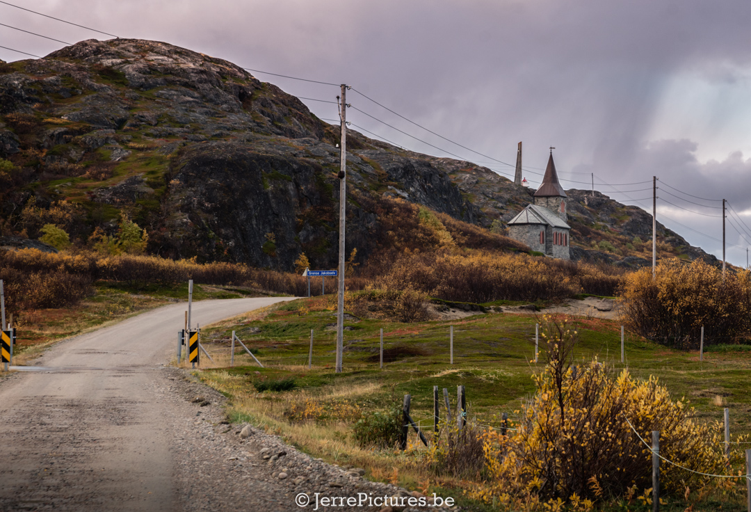
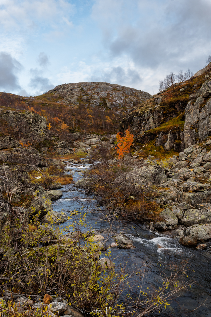
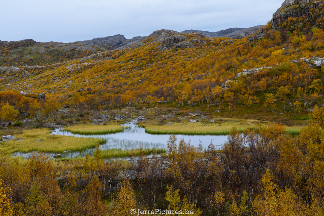
We’re in the year 2019, finally arriving at the place I had been eagerly looking forward to, the ‘King Oscar II Chapel’. Until recently, I had never heard anything about this chapel, but I stumbled upon it by chance through my then girlfriend’s (now ex-girlfriend) daughter. She gave me a beautiful booklet about North Scandinavia for Father’s Day, and I was immediately captivated when I came across a photo of it. I looked it up and found that it could be reached via the Fv8860, and based on my experience, Fv roads often prove interesting to me. As I drove towards it, it felt like a dream. The route alone is a combination of Tundra and Taiga as if Mother Nature couldn’t decide. Not only did I pass by Norway’s oldest mountain plateau (N69° 42′ 59.856″; O30°31 9.771″‘), which is said to be nearly 3 billion years old, but the road also took me right past the border checkpoint with Norway. What made it even more exciting was that the paved road suddenly turned into a gravel road. During my youth, I read a book by Anton Quintana called “Padjelanta.” It’s about a boy who grows tired of city life and seeks refuge in the tundra. It’s a shame that the Dutch book was never released in another language because it won numerous awards. However, I felt a strong connection to the Swedish boy portrayed in the story, it felt as if I was being drawn into that adventure once again. And let’s be honest, that’s how you want to travel as an overlander: reaching destinations where there are no paved roads. Furthermore, you are slowly transported back in time here, but it also makes you aware of the tense relations between Norway and Russia. Signboards clearly indicate the rules to maintain the optimal relation between the two countries (not only between these two countries but also between NATO and Russia), which I will delve into later.
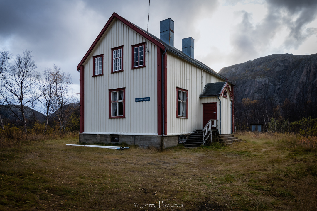
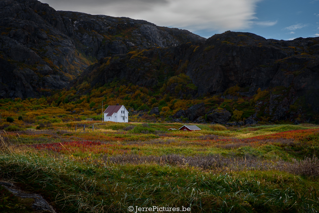
Along the way, I pass by an abandoned school. In my photos, you see a toilet standing outside a small school in the distance. I don’t need to tell you how cold it can be in Northern Norway, but due to global warming, it is here also a few degrees warmer. However, when you see photos of the history, you can imagine what it must have been like for the children to go to school here at temperatures of -20°C (-4°F) and then have to walk to those freezing cold toilets. It must have been truly harsh times! Officially, no one lives in the village anymore, and all the houses are locked with a padlock. When you look inside, you are almost further teleported back in time. It touches me in some way.
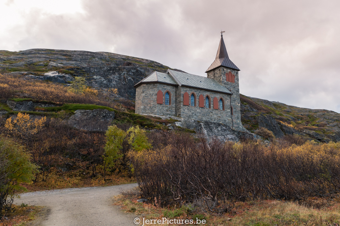
Eventually, I arrive at one of the biggest checkmarks on my list, the King Oscar II Chapel. As I step out of the car, I notice the harsh and incredibly cold wind. I check the thermometer in my car and see that it’s 2 °C, but my phone’s wind chill temperature reads -8 °C. In the distance, I hear the waves of the Barents Sea crashing forcefully against the rocks. It almost seems like the Barents Sea wants to destroy everything in its path. During my initial exploration outside, I feel my forehead skin cracking and my lips splitting apart. I quickly reach for my jar of petroleum jelly, but it’s too late. Little did I know, this was just a precursor of what was to come.
While driving here, I constantly pass along the Pasvik River (known as the Pasvik River in Norway and the Jakobselva in Russia). Only Norwegian citizens are allowed to fish in the river! If you look closely, you’ll see military presence on both sides. You can’t help but feel constantly watched. Along the road to this place, you drive just a stone’s throw away from the Russian border. However, there’s one problem: signs along the road clearly indicate that it’s not even allowed to throw stones toward Russia! So be warned! The border literally lies in the middle of this little river.
King Oscar II Chapel is a parish church of the Church of Norway in the municipality of Sør-Varanger, in the Troms og Finnmark county, Norway. It is located near the village of Grense Jakobselv, about 500 meters from the border with Russia.
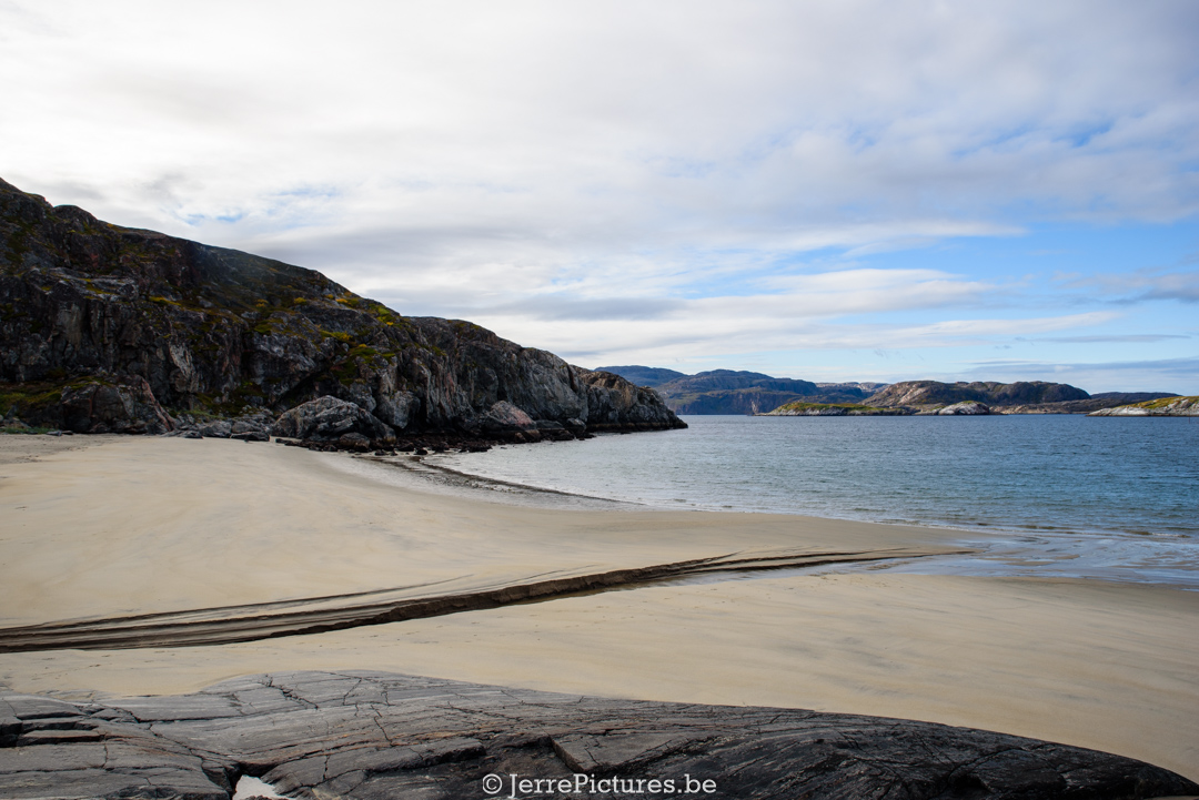
After my initial exploration, I decided to drive all the way to the northeasternmost point of Europe where it ends at the Barents sea. Arriving at that spot, no matter how small the area is, I am completely enchanted by the beauty of nature. Even the beach is mesmerizing. You would almost think you’re on a secluded piece of tropical paradise. However, the temperatures quickly remind you that it’s not the case. The cold continues to bother me, even though it’s only 2°C (despite later on my journey I’ll face temperatures of -22°C).
…..Hunger starts to nag at me, but I noticed an isolated parking lot near the church. I decide to drive there and park my car, sheltered from the wind by the King Oscar II Chapel. As soon as I step out, I immediately feel the difference—no wind… What a blessing! I gather my photography equipment and start taking some pictures. While capturing the moment, I notice several observation towers and a remarkable pillar on the Norwegian side. Apparently, that pillar is strategically placed to hinder the Russians from intercepting certain communications. It also reflects the radar image, preventing further visibility. Somehow, I still had the feeling that I was constantly being watched. The outcome of my photos isn’t exactly what I wanted, but the cold and my hunger are truly getting to me, something that doesn’t happen often. So I let it be and lower the tailgate of my vehicle to cook my dinner.
Suddenly, I notice a car with a Russian license plate constantly driving back and forth. After the fifth time, people in civilian clothing step out and approach the inlet where I am. There’s a somewhat tense atmosphere, but I greet them kindly, and the men decide to leave. I knew that in the region, you’re not allowed to use camera lenses larger than 200mm, as it’s clearly stated, I had a 300mm lens with me, but I hadn’t used it, and honestly, what do they have to say on European territory… but you never know what they are capable of… Initially, I had planned to spend the night there, but my intuition told me it wasn’t a good idea. While doing the dishes after preparing my dinner, a Norwegian man suddenly stopped and showed interest in my car. He thought it was cool and asked where I was from. I told him I was from Belgium and that I had driven all the way here, “At this time of the year?” he asked. He looked surprised and thought it was cool. He told me he lived in Kirkenes and had just finished fishing, and he invited me to take a warm bath at his place. I couldn’t refuse such an offer. So, I decided to follow the man. The reason(trustable)? In the meantime, he received a phone call from his wife during our conversation, and they spoke in pure Norwegian, so I had confidence in him.
Once at his house, he introduced me to his wife and their two children. After a warm bath, I started asking some questions about the many Russian license plates I had seen. They told me that if you live in Kirkenes for about three years, you can cross the border without a visa, and the same applies to Russian residents on the other side of the border. There is an area of about 200 kilometers on both sides where you can travel without a visa as a resident. This is because in the past, mainly Sami people lived in this area, who traveled with their reindeer, and animals don’t recognize borders. That’s why an exception was made. I can’t tell you if this still applies during the tensions in 2023.
I also told them about my encounter with the Russians. The man furrowed his brows and started speaking slowly as if weighing his words. He told me that in 2017, a retired employee, Frode Berg, from the Norwegian border post was arrested on suspicion of espionage. Since then, it seems that tensions have increased again, and there is speculation in the media that there might be a chance of him being exchanged. I will come back to this later in this blog post.
I also mentioned that I had endured some cold in Finland, but the cold and the strong northerly wind combined with the salt in the air on the Barents Sea dried out my face and caused my skin to crack. “Oh,” said the woman, “wait a moment.” She went away and not long after, she appeared with a jar. “Here,” she said, “you can have this. It’s for hands and face. The problem is,” she continued, “the products you’re used to using often contain a lot of moisture, and that makes your skin crack,” I asked her what she wanted in return, but she insisted on not wanting anything. All in all, it was a pleasant evening, and I learned a lot!
Capturing the Enchanting Landscapes of Grense Jakobselv: A Photographic Journey
A nerdy deep dive into Grense Jakobselv
THE FORGOTTEN HISTORY OF EUROPE’S EDGE
Rense Jakobselv, an abandoned Norwegian settlement on the edge of the Russian border, has a little-known fact: it is the northeasternmost point of mainland Europe.
The Sør-Varanger area in Arctic Norway, which shares a 195 km border with Russia, was first inhabited by the Skolts, a Sami ethnic group widely regarded as the indigenous population of Fennoscandia: a geographic region encompassing the Russian Kola Peninsula, Karelia, the Scandinavian Peninsula, and the northern parts of Finland and Norway.
The Skolts traveled relatively freely throughout Fennoscandia until a treaty in 1326 between the Republic of Novgorod and Norway closed off the border. However, the delineation between the two countries was not determined by a logical land boundary or an arbitrary line on a map, as one might typically expect. Instead, it was designated as a territorial entity, allowing the Norwegians and the Novgorodians to tax the Sami communities fairly. In the Middle Ages, these jointly controlled areas were known as border markers and were widely used throughout Europe to maintain security and promote interregional trade.
The treaty remained in effect for approximately five hundred years until the Russian Empire and Norway drew an official boundary line in 1826 to settle minor border disputes. However, in Grense Jakobselv, Norwegian and Russian fishermen continued to quarrel over the demarcation of the border and ownership of fishing grounds at the mouth of the Jakobselv River and the wider area of Varangerfjord, Norway’s most eastern fjord.
The Norwegian Ministry of Internal Affairs sought a way to keep the ongoing maritime disputes under control. Eventually, they sent Lieutenant Commander Heyerdahl from Oslo to assess whether regular supervision of fishing by the Royal Norwegian Navy could be a straightforward solution. By that time, numerous Norwegians and Kvens, a Finnish ethnic minority, had already settled in the region, bringing with them Lutheranism. However, at the time of Heyerdahl’s arrival, the community had no chapel for worship and used the Prestestua, a wooden hut for traveling clergy, which is said to still stand partially in ruins. Twenty miles southwest, in the Russian village of Boris Gleb, the Kremlin housed an Orthodox church that served as an active border marker. So, Lieutenant Commander Heyerdahl decided to follow a similar approach. He built the King Oscar II Lutheran chapel in Grense Jakobselv, just 500 meters from the Russian border. The chapel was completed in 1869 and still stands today as a symbol of the area’s history and religious significance.
In the following decades, the population of Finnmark, the region where Grense Jakobselv is located, began to grow. This was partly due to the emerging iron ore industry. At that time, a young photographer named Ellisif Ranveig Wessel lived in the nearby town of Kirkenes with her husband. Ellisif witnessed the demographic and industrial changes taking place in the region and their impact on the traditional Sami culture. She embarked on an ambitious project to document the transition from the far north to the 20th century.
With her dedicated work, Ellisif created one of the most recognized and extensive photographic collections of Grense Jakobselv, as well as numerous other locations and landscapes in Finnmark. Her photos offer a fascinating glimpse into the past and depict both the natural beauty of the region and the lives of the people who lived there. After quite a bit of research, I came across a Saami blog on Flickr, and it seems that many of her photos are housed in the Preus Museum. However, I’m not sure if they are currently on display and available for viewing.(it could be that they are only viewable @Flickr)
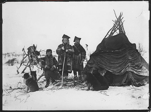
Photo by Preus museum, 2010.
 FLICKR
For more info visit the site of:

 preusmuseum.no
Although the border areas around Grense Jakobselv were influenced by historical events such as the Russian Revolution of 1917, the Battle of Petsamo in 1939, the German occupation during World War II, and the Cold War, there seems to be much that has remained unchanged, apart from the lack of residents. While only 13 houses remained standing after the liberation of Kirkenes (on the 24th of September 1944). Everything I have described so far is actually clearly depicted by Jeremy from T1D Wanderer in his YouTube vlog titled “Tension and beauty on the Norway-Russia border at Grense Jakobselv.”
Today, Grense Jakobselv is a ghostly settlement where visitors can enjoy the silence and the intriguing history that has unfolded in this overlooked outpost on the edge of Europe. It is a place that embodies the solitude and enchantment of the northern landscape while also reminding us of the complex relationships between borders, cultures, and history.
THE HISTORY OF KING OSCAR II CHAPEL AND ITS ORIGIN OF THE NAME?
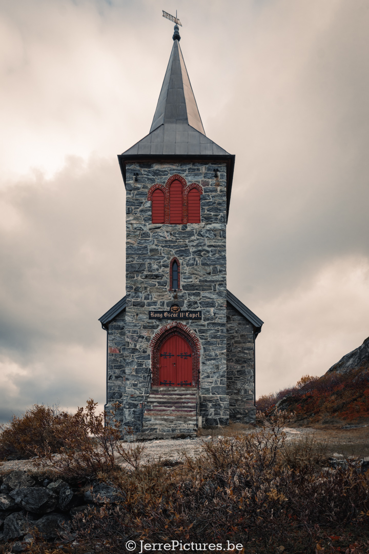
You have already received the history in the previous part, but to summarize: The Norwegian Ministry of Internal Affairs sent Lieutenant Commander Heyerdahl to assess the maritime disputes. He built the King Oscar II Lutheran chapel in Grense Jakobselv, near the Russian border. Completed in 1869, the chapel is a symbol of the history and religious significance of the area.
In 1873, King Oscar II of Sweden and Norway visited the chapel, and in commemoration of this visit, he donated a marble plaque to the chapel with bilingual inscriptions: “Kong Oscar II hørte Guds ord her den 4de Juli 1873” (Norwegian language) and “Gonagas Oscar II gulai Ibmel sane dobe dam 4 ad Juli 1873” (Northern Sami language), which means “King Oscar II heard the words of God here on July 4, 1873.” At the same time, he expressed his desire to name the chapel after himself, and thus the members of the congregation made a name sign for him that still hangs above the door.
This event illustrates the historical significance of King Oscar II’s visit to the chapel and his wish to associate his name with it. It also highlights the connection between the king and the religious community that used the chapel. The gesture of the marble plaque and the name sign testify to the royal recognition of the chapel and its role as a place of religious services and spiritual significance. Previously, the chapel was called “Grense Jakobselv Kapel,” named after the river it is located by, the Jakobselva.
The opening hours of the church vary annually, but information can always be obtained by contacting the following address: kirken@sor-varanger.kommune.no
IMPORTANT CONSIDERATIONS WHEN VISITING NEAR THE RUSSIAN BORDER:
When approaching the Russian border, you are often warned with signs that display clear guidelines which must be followed.
It is prohibited to:
- Cross the border by land, water, or air
- Make contact across the border
- Engage in offensive acts towards/over the border Remove, damage, or destroy border markers
- Photograph Russian military personnel and equipment in an aggressive or provocative manner
- It is also prohibited to use telephoto lenses exceeding 200 mm and/or tripods.
Additionally, it is advised that the area is monitored by surveillance cameras in accordance with the Personal Data Act §40 and the Defense Personal Data Regulations §8-4b.
THE LAST COTTAGE ON THE NORTHEASTERN EDGE OF EUROPE
When you stand there, you have the Varangerfjord and the Barents Sea in front of you. This sea area is known for its heavy storms. On clear days, you can see all the way across the fjord to the easternmost point of Norway, Kibergodden. To the east, you can see Fiskerhalvøya in Russia. This is where modern Norwegian whaling began between 1860 and 1910. In Southeast Varanger, there were a total of five whaling stations.
The underlying rocks here can be as old as three billion years. The gneiss here, known as Barents blue, is used as a building material. The sand dunes near the fjord are typical of river estuaries in Finnmark. Oriental plants like Siberian chives grow here, while in southern Norway, they only grow high in the mountains. You can even find them directly on the beach here.
This last house in Grense Jakobselv is a boating association located in a border area within swimming distance of Russia. The club is housed in a small red house known as the clubhouse of the Kobbholmen-Grense Jakobselv boating association. The boats in this association must not exceed 17 feet, and it becomes clear why when you learn more about the location.
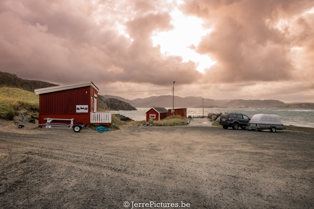
The boating association is located in a highly exposed area where white sandy beaches meet the Barents Sea and Norway meets Russia. The season for the forty members of the association begins when the road over the mountain has melted enough for them to drive their cars with boats on trailers. Typically, the season lasts from May to October. During the rest of the year, the only way to reach the small red clubhouse, marked as “Kobbholmen Boating Association,” is by snowmobile or tracked vehicle. Additionally, due to the location and tides that can reach up to four to five meters, the members have to carry the 15 boats all the way to the shore each time they go out. An attempt to keep a 15-foot Ranaplast boat moored ended up on land due to groundswells, where the waves become so large and powerful that it is impossible to keep the boat anchored. For practical reasons, there is a maximum limit of 16-17 feet so that the members can handle and tow the boats themselves. They must also always consider the tidal schedule since there are only two four-hour periods per day when they can go out to sea and return.
Despite the challenging conditions, there is vibrant beach life in Grense Jakobselv during the summer. The local residents have left due to the inaccessibility during winter, but in summer it becomes a place for barbecues, swimming, and family fishing competitions. However, the old hotdog kiosk on the beach is permanently closed.
Originally, the use of boats in the border area of Sør-Varanger was driven by the need to obtain fish, berries, seagull eggs, and other edible items to adorn the dinner table. Many of the cottages in the area were also only accessible by boat. At that time, the concept of a “pleasure boat” was associated with city dwellers and the harbor in Kirkenes. However, when the old pier was destroyed by a storm in 1992, something had to be done.
They realized that they would be better off working together rather than individually, so they founded the Kobbholmen Boating Association. The association is named after the nearby Kobbholmfjorden. Since everything in the Grense Jakobselv area is named that way, they opted for something different. Several members of the association have cottages in Kobbholmfjorden, and despite being closer to the city, they wouldn’t want to trade places with the boating association there. Nowadays, men also bring their families on trips. The women are strong, and they respect the weather. Twenty-five degrees on land can mean ten degrees at sea, so they must be well-equipped. Additionally, they risk losing their crew if they push the boats in bad weather.
The boats in the association are monitored by the border guards since Grense Jakobselv itself resembles more of a current than a river, and there is only a four to five-meter distance from the road to Russia. The association is very pleased with this arrangement, not only to prevent theft and vandalism but also to ensure the safety of the boats,
but also for the safety of its members. If someone ventures out to sea and encounters engine or steering problems, they risk drifting away unnoticed. The history of the area reveals that there used to be a ferry with a fixed route and a long pier, but they have been lost over time and storms. The boating association relies on its members to maintain and improve the area, and they carry out clean-up campaigns twice a year. You can see photos of these activities on their Facebook group; https://www.facebook.com/groups/726437940874371/.
like cleaning the beach and suroundings: https://www.facebook.com/photo/?fbid=1988977267793728&set=g.726437940874371
The proximity to Russia also brings interesting discoveries, as Russian objects sometimes wash ashore along with remnants from the German era.
In the area, the main fishing targets are species such as coalfish, cod, and haddock, although the cod population has decreased in recent years. Wolffish and halibut have also become less common due to the invasion of Russian crabs, which get entangled in nets and cause damage. The boating association appreciates the opportunity to catch crabs and shares a simple method for it: tying a rope in the water so that the crabs get trapped in it and then pulling it up. The “båtgutta” (boat guys), as they call themselves, take pride in their membership in Norway’s most exposed and resilient boating association. They are determined to face the challenges of their unique location and continue to enjoy the beauty of Grense Jakobselv. Their ongoing journey involves exploring the stunning natural surroundings, preserving their traditions, and strengthening the bonds within the association and with the local community.
The Grense Jakobselv boating association is not just a place for adventurous boat trips and fishing, but also a tight-knit community where friendships are forged and memories are made. They celebrate the summer with various activities on the beach, where families come together for barbecue parties, swimming, and fishing. Despite the closure of the old hotdog kiosk, the association remains a vibrant center of social interaction and community spirit.
With a rich history and a unique location on the border between Norway and Russia, the Grense Jakobselv boating association continues to enchant its members and visitors with the power of nature and the resilience of the human spirit. Exploring this special association and its surroundings provides profound insights into the unique experiences, challenges, and connectedness of the people involved.
IS GRENSE JAKOBSELV ACCESSIBLE BY CAMPER?
Well, get ready for an adventure! Despite being an unpaved road, you can reach the northeasternmost point of Europe even with a camper. However, be aware that the roads there are quite rugged and filled with potholes. From May to October, getting there is not a problem (provided that the snow has melted). But during the harsh winter months, the village can only be reached by snowmobile or tracked vehicle. In the past, expeditions were organized from Kirkenes to this location via snowmobile.
For more information, please visit:

 Visit Kirkenes Region
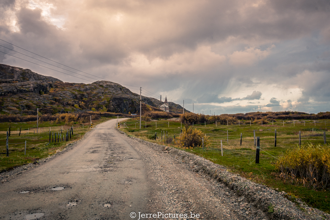
TENSION AT THE BORDER DURING MY VISIT DUE TO THE SAGA SURROUNDING FRODE BERG
So what’s the deal with the tension at the border? Why was the tension so high in October 2019?
After hearing the story during the visit of this friendly Norwegian man, I had to dig into it when I got back home. I also discovered, upon arriving home in November 2019, that this man had returned home thanks to a spy exchange. Let’s delve into the story. It also gives a bit of an idea and reflects the tension at the border.
Norway has been living in tension since the arrest of Frode Berg, a former border guard, on charges of espionage in Moscow. This shocking event has shaken the country and marks the first time since World War II that a Norwegian citizen has been convicted of espionage.
Frode Berg, a retired border guard from Kirkenes, was arrested in 2017 and subsequently accused of conducting espionage activities for the Norwegian intelligence service. He was accused of receiving secret naval documents from a former Russian police officer. Berg denied the espionage charges but admitted to acting as a courier for the Norwegian intelligence service (whether under pressure to obtain better conditions).
Berg’s arrest caused a national shock and put Norway on high alert. It was an unprecedented situation that strained relations between Norway and Russia and increased diplomatic tensions. It served as a reminder of the dangerous geopolitical games being played in the far north, where Norway shares a border with Russia.
While Frode Berg’s case continued, another remarkable incident occurred in northern Norway in 2019. A white dolphin with a Russian-branded harness and camera attachment appeared in the water. This sparked the imagination of people in nearby Kirkenes, who joked that they finally had a spy to exchange. The bizarre incident fueled speculation and added an extra layer of mystery to the region. Ultimately, he was sentenced to 14 years in prison in April 2019.
Eventually, after prolonged efforts and diplomatic negotiations, a spy exchange took place between Russia, Norway, and Lithuania. The exchange was made possible by Lithuania’s willingness to amend its legislation. The Lithuanian parliament changed the penal code to grant the president the power to grant pardons to Russian spies, which was a crucial step in completing the exchange.
The spy exchange took place at a border checkpoint in Lithuania, where the prisoners were transferred to their respective countries. Frode Berg was taken to the Norwegian embassy in Vilnius and would soon be reunited with his family in Norway. The exchange was praised as a diplomatic achievement and a sign of cooperation among the involved countries.
The release of Frode Berg and the other prisoners marked a turning point in their lives and brought relief to their loved ones. It also represented a moment of hope for potential improvements in relations between Norway, Russia, and other involved countries. The successful completion of the spy exchange gave rise to optimism that diplomatic channels would remain open for future cooperation and conflict resolution.
The events surrounding Frode Berg and the remarkable spy exchange served as a wake-up call for Norway and the international community about the increasing complexity and risks in the geopolitical landscape of the North. The country will undoubtedly continue to work on strengthening its security measures and maintaining robust intelligence and diplomatic capabilities.
While the events continue to live on in Norway’s collective memory, the story of Frode Berg and the spy exchange serves as a reminder of the fragility of international relations and the ongoing need for dialogue and cooperation to resolve conflicts. It is a testament to the courage and determination of individuals and nations to pursue justice and promote peace.
The story of Frode Berg and the spy exchange will undoubtedly find its place in Norway’s history books and be remembered as a turning point in the country’s modern history. It highlights the ongoing challenges and complexities nations face in an ever-changing world, and the importance of diplomacy, justice, and international cooperation to ensure a secure and stable future.
With Frode Berg’s release and the closing of this chapter, Norway can look forward to a new era of security, cooperation, and hope, drawing lessons from these historic events to strengthen its position and work towards a peaceful future for its citizens and the global community.
my sources for the Frode Berg’s saga:

 www.bbc.com
WHISPERS OF THE BARENTS SEA: A GLIMPSE FROM GRENSE JAKOBSELV
Return to Grense Jakobselv: An Unexpected Warmth in 2024
After my first adventurous visit to Grense Jakobselv in 2019, I felt a strong urge to revisit this remarkable place. This time, it wasn’t just for myself, but to share this fascinating location with my girlfriend, convinced she too would be enchanted by the rugged beauty of this remote borderland.
Rediscovering the Journey
Five years after my initial visit, the journey to Grense Jakobselv seemed even more spectacular than I remembered. Although I had previously traveled the route from the Norwegian to the Russian border and to the furthest tip, it appeared I had erased some parts from my memory because I was amazed once again by its beauty. Perhaps the absence of tourists or subtle changes in the landscape had altered the route, or maybe it was just the company making everything seem more beautiful. The path was a surprising and spectacular display of natural splendor, with visible welcomes from both the Norwegian and Russian sides, although political tensions sometimes cast a shadow over this beautiful landscape. But it certainly wasn’t the warmth of the people living there that was lacking… speaking of warmth.
An Unexpected Twist
Upon arrival, we stepped out and were greeted by an unexpected warmth—and no, this time I’m not talking about the warmth from the attractive woman who was waving at us from her terrace in her bathrobe… no—it was the air—15 degrees Celsius, which is unprecedented for this part of the world at this time of year according to the locals. It was the warmest temperature they could recall. The irony of having prepared my girlfriend for sharp cold, only to stand in what felt almost like a mild spring day—no, let’s say a summer day for this region. The moment was a perfect reminder of how unpredictable and surprising nature can be.
Savoring the Moments
Despite the unexpected warmth, both from the few residents and the day’s temperature, it allowed us to enjoy our surroundings without the usual barriers of heavy coats and shivering cold. We enjoyed a delicious meal before continuing our exploration. This felt like a rare gift from nature, a break in the usual harsh climate, allowing us to experience the rugged beauty of Grense Jakobselv with unexpected gentleness.
This return to Grense Jakobselv was more than just a repeat of a past journey; it was a renewal of my already great appreciation for this place and an opportunity to observe the constant changes in our world. It proved once again that every journey is unique, and what we think we know can always surprise us anew.