On a dark, foggy evening, I embarked on the notorious Fv500 road to Lysebotn after mistakenly setting my GPS to pedestrian mode instead of vehicle mode, leading to a detour of 600 km. Despite the darkness and fog dampening my spirits, my adventurous heart was undeterred. As I drove along the serpentine road, the headlights of my car pierced through the dense darkness. Out of nowhere, a sharp hairpin turn appeared, and to my surprise, I encountered a flock of sheep blocking the road. Startled but resolute, I managed to avoid a collision by braking quickly—swerving wasn’t an option due to the narrowness of the road, but thankfully, my reduced speed helped.
This unexpected encounter reminded me that I was in the middle of the night on one of Europe’s most remote mountain roads. With renewed determination, I continued my journey towards Lysebotn, each kilometer of the narrow, winding road demanding my undivided attention.
Upon reaching the small village at the eastern end of the Lysefjords, I felt a deep sense of accomplishment. Exhausted from not having slept the night before, I had nevertheless completed the route as I had envisioned it, albeit in the middle of the night. This adventure served as living proof of the claims that this road is one of Europe’s most dangerous, undoubtedly contributing to its status as a top tourist destination in Southern Norway. Little did I know that I would later encounter much worse, although, to be fair, the fog and night did increase the difficulty somewhat.
The Fv500 is renowned for its spectacular views and challenging path, attracting about 100,000 tourists annually (unfortunately), all eager to glimpse the famous Kjeragbolten. This iconic boulder, wedged between two mountain walls at an elevation of 1000 meters above the Lysefjord, is a highlight for many.

However, standing in lines in nature is not for me. But the true gem of the Fv500 reveals itself just past the Kjeragbolten parking lot. Here begins a section of the road described by seasoned adventurers as intensely challenging. For those traveling with large campers, this might be the endpoint; the road beyond this point requires significant driving skill and concentration.
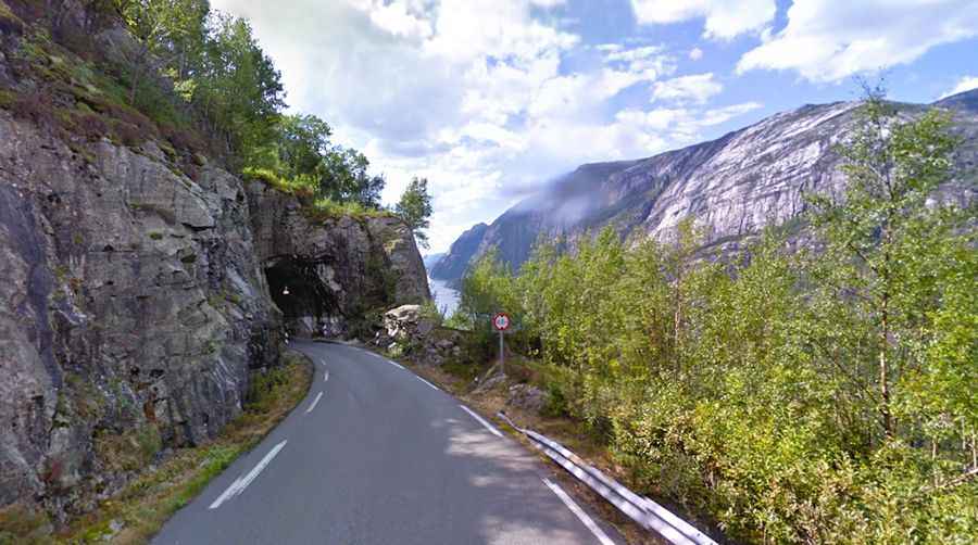
Further on lies a tunnel with a hairpin turn—a unique and unforgettable experience, particularly impressive during daylight. You will also pass the Lysebotn hydroelectric power plant, where water is sent 620 meters downward to turbines capable of generating up to 210,000 kilowatts of electricity.
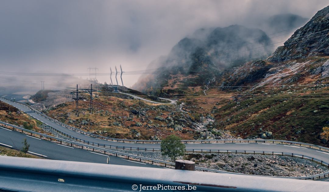
Despite being listed on dangerousroads.org and occasional tragic accidents (like the loss of a Polish woman during my visit, which was not directly related to the road itself), Lysevegen remains an unforgettable route. With its 27 hairpin bends and a total length of about 32 kilometers, it offers a challenging yet breathtaking experience for every adventurous traveler.
 www.dangerousroads.org
If you are seeking a path that poses a modest challenge but is undoubtedly ten times as beautiful, then Lysevegen is an experience you will not soon forget.
Kjerag or Kiragg is a mountain in Sandnes municipality in the province Rogaland in Norway. The 1,110-metre (3,640 ft) tall mountain sits on the southern shore of Lysefjorden, just southwest of the village of Lysebotn. Its northern side is a massive cliff, plunging 984 meters (3,228 ft) almost straight down to the fjord and that makes it spectacular, a sight that attracts many visitors each year. Another tourist attraction, the Kjeragbolten, a 5-cubic-meter (180 cu ft) stone wedged between two rocks is located on the mountain. The problem is that is too famous for me, you read a lot of articles of people standing in line in order to have their shot, and you will pass a lot of people on their flip-flops walking towards this point…what standing in line?? No no that is not my cup of tea. Another famous point is The Kjeragfossen waterfall plunges off the mountain down to the fjord. It is one of the tallest waterfalls in the world. But because
Kjerag is a popular hiking destination. Some go there because Preikestolen has become too crowded, some to jump onto Kjeragbolten and some BASE jumpers from all over the world go there to jump off the high cliffs. Kjerag is also a popular climbing destination, with many difficult routes going up its steep faces.
The easiest ascent starts from the visitors center Øygardsstølen, with a 2.5-3-hour walk each way. From Stavanger, it is roughly a 2-hour drive (closed in the winter season). One can also take the tourist ferry from Lauvvik to Lysebotn in the summer. The best season for walking is considered late June to September depending on snow conditions
Oh yes, dear friends…there is something that drives me completely crazy during my travels and that is people stacking stones. here too you see 100 piles stacked together, why is this necessary? In Iceland, I once made one because a route was no longer visible and that is what these piles of stones were initially intended for. to be able to orientate yourself on unmarked routes if you have to walk back a bit. or to point out the direction to the people who will come after you one day.
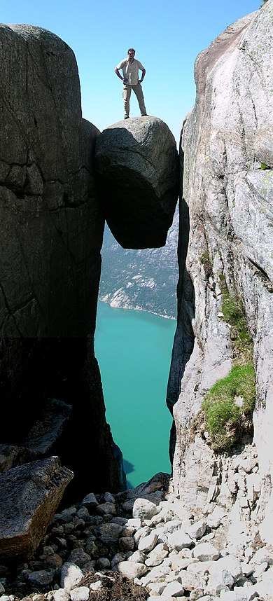
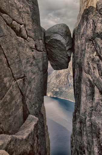
Kjeragbolten
Like I told you, Kjeragbolten is a 5-cubic-meter (180 cu ft) boulder wedged in a mountain crevice by the edge of the Kjerag mountain. It is possible to walk onto the rock without any equipment, but there is a direct 241-meter (791 ft) drop below and then another 735-meter (2,411 ft) gradient down to the Lysefjorden. The name means “Kjerag Boulder” or “Kjerag Bolt”.
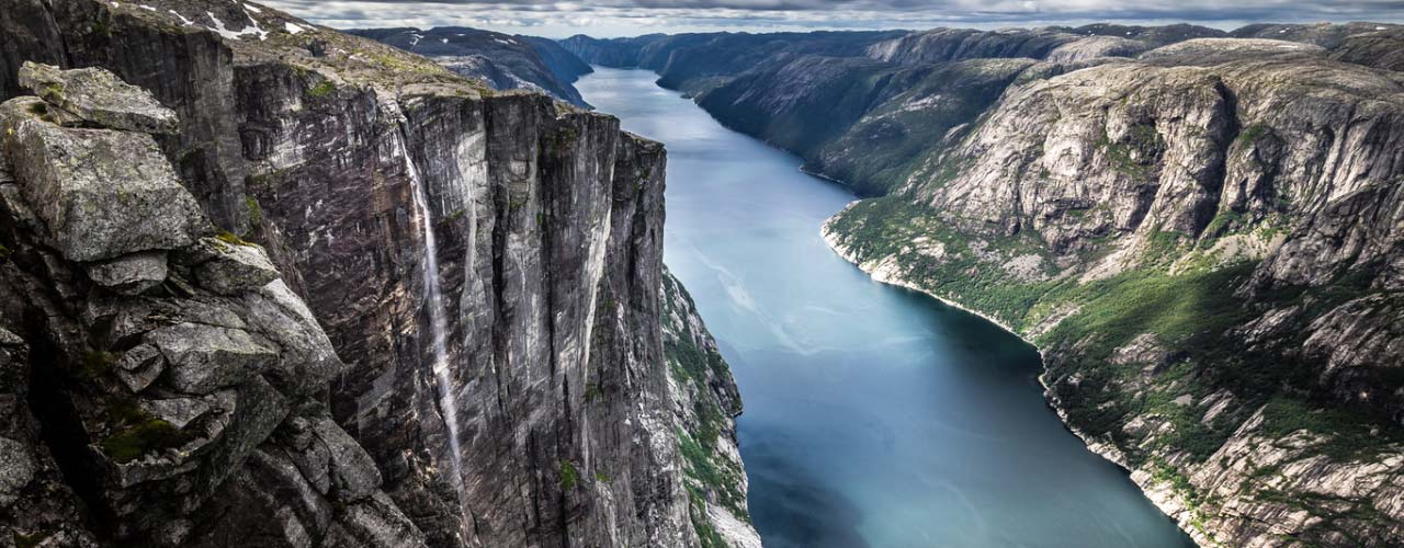
Kjeragfossen
It is one of the highest waterfalls in Norway and one of the highest in the world. It is a plunge-style waterfall that is usually only active about 5 months of the year
And that is why this waterfall is less known. Kjeragfossen is definitely worth seeing in winter and spring. In summer and autumn it regularly dries up, so some people are disappointed when they come here. Sometimes it flows again after heavy rain…but it is true, what you think right now–> it is not the same. But still, if you are doing the hike expect nothing and you will be rewarded with a stunning view.
Best time:
If you want to see the waterfall in all its glory, lots of flowing water from 715 meters high in other words, you have to be here in the spring. Then much of the snow melts and the water flow is at its greatest. And if you want to avoid a lot of tourists, it’s useful to start the hike to Kjerag early. Bring a picnic, the Kjeragfossen is the ultimate place for a lunch break.
note; I did not visit it because there were too many tourists when I passed it.